
Description
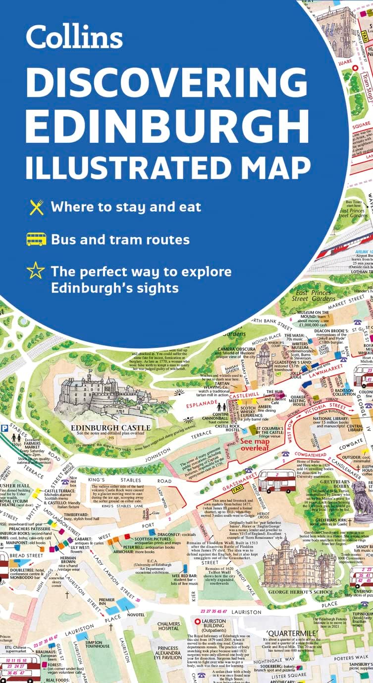
Book Synopsis: Edinburgh, home to the Scottish Parliament, is on the itinerary of many visitors to Scotland. This brand new edition retains the delightful water-colour mapping, with individual paintings of all the main sights and landmarks.Popular areas at larger scale, hundreds of shops, restaurants, cafés and bars, comprehensive travel information and index.
This map includes:
- Large-scale plans of the Castle, Royal Mile, Botanic Gardens, Leith and Newington.
- Shop-by-shop street maps of Princes Street, George Street, Victoria Street and the Grassmarket.
- Railway stations, bus routes, taxi ranks and car parks.
- Historical and contemporary anecdotes.
- Suggestions for day trips out of the city.
- Comprehensive index.
Area of coverage:
Covers the centre of Edinburgh from Inverleith Park in the north to The Meadows in the south, and from the Scottish National Gallery of Modern Art in the west to the Palace of Holyroodhouse in the east.
Details
If you're planning a trip to Scotland, make sure to include the charming city of Edinburgh in your itinerary. And to enhance your experience, we have the perfect companion for your exploration - the Edinburgh Illustrated Map Book. This brand new edition is filled with delightful watercolor mapping, featuring individual paintings of all the city's main sights and landmarks. With this map in hand, you'll have a visual feast of Edinburgh's beauty right at your fingertips.
Looking to explore specific areas of the city in more detail? The Edinburgh Illustrated Map Book has got you covered. It includes large-scale plans of popular spots such as the Castle, Royal Mile, Botanic Gardens, Leith, and Newington. Additionally, you'll find shop-by-shop street maps of famous shopping destinations like Princes Street, George Street, Victoria Street, and the Grassmarket. You won't miss a single hidden gem or trendy café with this comprehensive guide.
Not only does the Edinburgh Illustrated Map Book highlight the city's attractions, but it also provides essential travel information. You'll find railway stations, bus routes, taxi ranks, and car parks clearly marked, making it easier for you to navigate your way around. Moreover, this map includes historical and contemporary anecdotes, adding depth and intrigue to your sightseeing adventures.
No trip to Edinburgh is complete without exploring the surrounding areas. The Edinburgh Illustrated Map Book offers suggestions for day trips outside of the city, allowing you to discover even more of Scotland's hidden treasures. From picturesque landscapes to charming villages, the possibilities are endless.
Don't miss out on this invaluable tool for exploring Edinburgh and beyond. Order the Edinburgh Illustrated Map Book today and embark on your Scottish adventure with confidence!
Order now and start discovering Edinburgh like never before.
Discover More Best Sellers in Atlases & Maps
Shop Atlases & Maps

Rand McNally Easy To Read Folded Map: Massachusetts State Map
 Atlases & Maps - Rand McNally Easy To Read Folded Map: Massachusetts State Map

Rand McNally Easy To Fold: Texas State Laminated Map
Atlases & Maps - Rand McNally Easy To Fold: Texas State Laminated Map

Rand McNally 2024 Midsize Easy to Read - 100th Anniversary Collector’s Edition
 Atlases & Maps - Rand McNally 2024 Midsize Easy to Read - 100th Anniversary Collector’s Edition
 Atlases & Maps - National Geographic United States Wall Map - Classic (43.5 x 30.5 in) (National Geographic Reference Map)

Egypt Map (National Geographic Adventure Map, 3202)
Atlases & Maps - Egypt Map (National Geographic Adventure Map, 3202)

Texas Map (National Geographic Guide Map)
Atlases & Maps - Texas Map (National Geographic Guide Map)
 Atlases & Maps - National Geographic United States Map (folded with flags and facts) (National Geographic Reference Map)

Baja California Road and Recreation Atlas - 2nd Edition, 2024 (Benchmark)
Atlases & Maps - Baja California Road and Recreation Atlas - 2nd Edition, 2024 (Benchmark)
