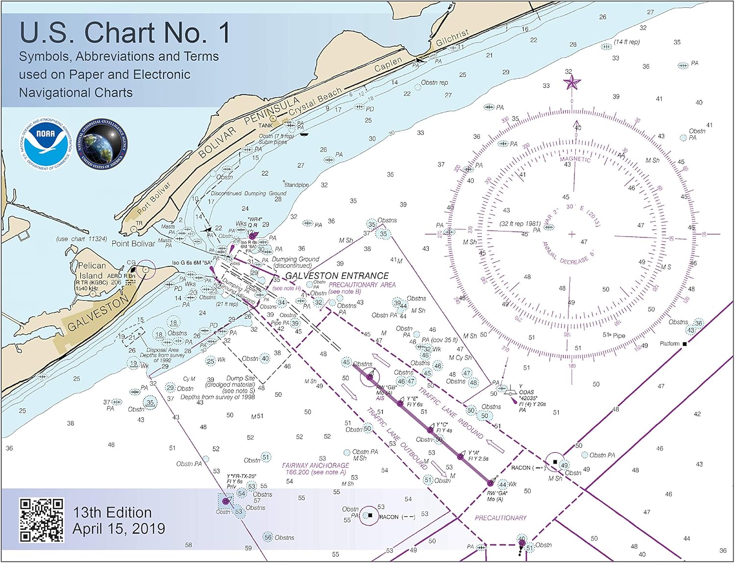
U.S. Chart No. 1 - 13th Edition: Symbols, Abbreviations and Terms used on Paper and Electronic Navigational Charts

$14.95
Description
Book Synopsis: This 130 page book describes the symbols, abbreviations, and terms used on paper NOAA nautical charts and for displaying NOAA electronic navigational chart (NOAA ENC®) data on Electronic Chart Display and Information Systems (ECDIS). The document also shows paper chart symbols used by the National Geospatial-Intelligence Agency and symbols specified by the International Hydrographic Organization.
In the back of U.S. Chart 1, there is additional information about the characteristics and appearance of buoys conforming to the IALA Maritime Buoyage System that is used by the United States and most other seafaring nations.
Some of the changes implemented in this new addition are listed in the table below:
| Chart No. | Symbol | Change Description |
|---|---|---|
| C 21 | Extended use of the dashed Intermediate River line symbol to also represent Intermediate Lakes. | |
| D 11 | Added new NOAA light gray line symbol for Hard Surface Road. | |
| F 29.2 | Added symbol for Bubble Curtain. Also called a pneumatic barrier, these consist of perforated pipe affixed near shore to the bottom of a body of water. As air is forced through the pipe, rising bubbles cause a wall of water to flow upward. The effect can stop or slow the passage of spilled oil or fish from passing through the barrier. | |
| H r | H s | Deleted entries for obsolete New Moon and Full Moon symbols, which at one time accompanied chart tide tables. |
| H t | Deleted entry for Current Diagram symbol, also called a current rose. These symbols are being removed on the next editions of the few charts in New England in which they currently appear. | |
| K 47 | Deleted the text based Oyster Bed symbol. NOAA now uses the international symbol for Shellfish Bed. | |
| K a | Changed description of this symbol from "Rock awash" to "Rock which covers and uncovers, (height unknown)" to align with K 11, which shows the same feature, but for which a height is known. | |
| N 12.2 | Added typical NOAA representations for Anchorages that reference the US Code of Federal Regulations (CFR). Text of relevant sections of the CFR are reprinted in Chapter 2 of each volume of the US Coast Pilot®. | |
| N 13 | Deleted text based symbol for Seaplane Operating Area. | |
| P 30.1 | Deleted the symbols shown for NOAA and NGA, which were incorrect. Both agencies portray Directional and Sector Lights in a manner similar to that shown by the international symbols. | |
| Q 51-53 Q 55-57 Q 59-63 |
Deleted entries for many specific types of Special Purpose Buoys and added the note, "Purpose of buoy may be shown by label." | |
| Q 130.1 | Added the Island of Taiwan to the list of western Pacific areas, which use the IALA B buoyage system. | |
| Q 130.7 | Deleted the Q 63 entry for "Emergency wreck marking buoy" and moved the renamed aid, "New danger mark" to Q 130.7. Paper chart and ECDIS symbols are now shown, as well as a depiction of the buoy in Appendix 1. | |
| S 4 | S 5 | Deleted NOAA symbols for Radar Reflectors, which are not shown on NOAA charts. |
| S 18.1-7 | Added paper chart and ECDIS examples for each type of Virtual Automatic Identification System (V-AIS) aid to navigation symbol. | |
| T 26 | T27 | Deleted entries for Distress Signal Station and Telegraph Station. Other types of Signal Stations remain. |
Appendix 1 Added depiction of a New Danger Mark in the appendix that shows examples of the aids to navigation in the IALA Maritime Buoyage System. A New Danger Mark entry was also added at Q 130.7.
Details
Are you a seafarer in need of a comprehensive guide to navigate the open waters? Look no further than the U.S. Chart No. 1 - 13th Edition: Symbols, Abbreviations and Terms used on Paper and Electronic Navigational Charts. This 130-page book is a must-have for sailors, providing descriptions of the symbols, abbreviations, and terms found on both paper NOAA nautical charts and Electronic Chart Display and Information Systems (ECDIS). With this invaluable resource, you'll have the knowledge to confidently navigate any waters.
One of the standout features of the U.S. Chart No. 1 is its inclusion of symbols used by the National Geospatial-Intelligence Agency and those specified by the International Hydrographic Organization. With this comprehensive amalgamation of symbols, you can ensure that you're familiar with the symbols used by seafaring nations worldwide.
Not only does U.S. Chart No. 1 cover symbols, abbreviations, and terms, but it also provides information about the characteristics and appearance of buoys conforming to the IALA Maritime Buoyage System. This system is used by the United States and most other seafaring nations, making it an essential reference for any sailor.
With the 13th Edition, U.S. Chart No. 1 has undergone several important updates. For example, new symbols have been added, such as the symbol for Bubble Curtain, which can help you navigate potential barriers in the water like spilled oil or fish. Obsolete symbols have been removed, ensuring that you have the most up-to-date information at your fingertips. These updates reflect the commitment of NOAA to provide accurate and reliable navigational resources.
Don't let uncertainty navigate your journey. Equip yourself with the U.S. Chart No. 1 - 13th Edition and gain the confidence to conquer the seas. Visit our website and order your copy today!
Discover More Best Sellers in Transportation
Shop Transportation
 Transportation - The Complete Book of Corvette: Every Model Since 1953 - Revised & Updated Includes New Mid-Engine Corvette Stingray (Complete Book Series)
 Transportation - Jeep Wrangler 4-cyl & 6-cyl Gas Engine, 2WD & 4WD Models (87-17) Haynes Repair Manual (Does not include info specific to diesel engine models. Includes coverage apart from specific exclusion noted)

Toyota Tundra 2007 thru 2019 and Sequoia 2008 thru 2019 Haynes Repair Manual: All 2WD and 4WD models
Transportation - Toyota Tundra 2007 thru 2019 and Sequoia 2008 thru 2019 Haynes Repair Manual: All 2WD and 4WD models

How to Rebuild GM LS-Series Engines (S-A Design)
Transportation - How to Rebuild GM LS-Series Engines (S-A Design)
 Transportation - CDL Practice Tests 2022-2023: The Most Up-to-Date Portable Practice Tests Workbook, with More Than 350 Questions and Answers to Pass the Commercial Driver's License Exam on Your First Attempt

Becoming A Pilot: What Every New Pilot Needs To Know To Save Time And Money In Flight School
Transportation - Becoming A Pilot: What Every New Pilot Needs To Know To Save Time And Money In Flight School

 Transportation - Jdm Coloring Book: for Adults over 100 Pages of 50 Best Japanese Model Cars with Detailed Coloring Pages for Stress Relief,relaxation|Gifts for JDM lovers.

Navigation Rules And Regulations Handbook (Color Print): Containing - International & Inland Rules
Transportation - Navigation Rules And Regulations Handbook (Color Print): Containing - International & Inland Rules
